Why Old City Streets Bend with the Ground
Learn how to read old city streets against slopes, ridges and watercourses, and distinguish terrain-shaped bends from routes that follow other clues.
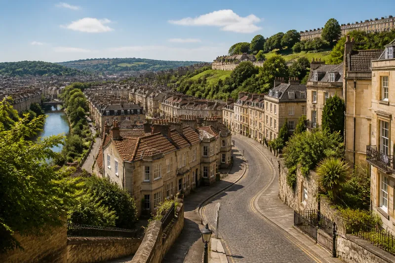
Old city streets often bend where the ground rises, falls or gathers water. To read those curves, compare the street line with contour patterns, ridge tops and drainage paths on a map; a bend is a clue to investigate, not proof of a single cause.
Start with the shape of the land
Use a topographic map if one is available. Closely spaced contour lines indicate a steeper slope; widely spaced lines indicate gentler ground. A street crossing several close contours is likely to climb or descend, while one that runs alongside them may be keeping to a more consistent level.
On a phone, switch to a terrain or topographic layer in a mapping app. A paper map with contour lines works just as well. Keep a standard street map nearby too: the terrain layer makes elevation legible, while the street map gives names and junctions you can match.
- Mark the street’s direction at each major turn.
- Look for contour lines that curve in the same direction.
- Note whether the street crosses a slope, follows it, or changes direction near a crest or hollow.
- Check the ground on both sides of the street; a curve may respond to a local feature rather than the whole hillside.
Contour lines are not a street plan. They show the broad shape of the land, and their detail may be too coarse to explain a small lane’s exact course. Treat them as a way to form a question: what change in the ground occurs near this bend?
Notice when a street follows a ridge
A ridge is higher ground with slopes falling away on either side. Streets along a ridge may trace its crest, particularly where a narrow route connects higher neighbourhoods. On a map, look for a line of high ground and check whether the street runs close to it, rather than merely crossing it.
Ridge-following streets can have an irregular line even when the crest seems straightforward. The ridge may divide into spurs, or the route may shift to avoid a steep patch. A street might also run on a shoulder below the crest, where the ground offers a less abrupt route and access to buildings.
Use nearby cross streets as a check. If they descend away from the same long, raised line on both sides, a ridge relationship becomes more plausible. If the apparent high line is interrupted or the cross streets climb towards it from only one side, the pattern may instead reflect a spur, a slope edge or an altered street network.
Read slopes through the direction of travel
A street that winds across a slope can gain height gradually instead of climbing directly uphill. Compare its route with the contour lines: a street that tracks roughly alongside them is contour-following, while one that cuts across them changes elevation along its length.
Do not assume every curve is a deliberate switchback. A broad bend may reflect a gradual landform, a route around a spur or a connection between districts at different levels. A sharp turn can come from a junction or property boundary rather than the slope itself. Look for a repeated relationship over several blocks before interpreting an isolated corner.
Say you notice a street curving around the side of a hill on a terrain map. If its line stays near the same contour for several blocks, while nearby streets climb directly towards the crest, you might infer that the curving route follows the slope. That reading remains provisional: compare the bend with the junctions and neighbouring streets before attributing its shape to the ground alone.
Trace watercourses without mistaking every hollow for a stream
Water tends to move towards lower ground, so valleys and drainage lines can influence street alignment. On a contour map, contour lines form a V-shaped pattern where they cross a valley; the point of the V generally indicates the direction of higher ground. A street may follow the valley floor, skirt its edge or cross it at a convenient point.
Modern maps can help identify named creeks, canals and rivers, but small drainage channels may be missing or concealed beneath built-up areas. A dip between two slopes can also be a dry hollow, not a flowing watercourse. Compare the contours with visible waterways and avoid treating the map’s blank spaces as confirmation.
Where a street tracks a watercourse, check whether it follows the channel closely or bends around a wider low area. A route beside a creek may have shifted over time, and present-day street alignment cannot by itself establish the original reason for the road. The map shows a spatial relationship; interpreting its history requires more evidence.
Use a careful map-reading sequence
Choose one short street section with a clear bend and work outward. This keeps the reading grounded in observable features rather than a city-wide theory.
- Locate the bend. Match the street name and nearby junctions on a street map to the same place on the terrain layer.
- Read the contours. Note whether lines bunch, spread, turn around the street or form a valley pattern.
- Check direction. Trace the street before and after the bend and decide whether it follows, crosses or avoids the landform.
- Compare nearby routes. Look at parallel streets, cross streets and paths. Similar alignments may support a terrain connection; a single matching curve may be coincidence.
- Consider another cause. A junction, a boundary, a bridge approach or a route connecting established places can also explain a change in direction.
- Write a qualified note. Record what the map shows, then phrase the interpretation as a possibility rather than a certainty.
For example, imagine a map reader finds that one street bends beside a mapped creek, but a second street nearby follows the same curve without approaching the water. The reader can note that the first bend may relate to the creek’s low ground, while the repeated curve suggests the broader street layout may also matter. The useful result is a more precise question, not a claim that both bends share one cause.
What can a street bend tell you?
How can I tell whether a street follows a contour?
Compare the street’s course with contour lines across several blocks. If the route runs roughly alongside them and crosses few of them, it may follow a similar elevation, though the map’s level of detail can obscure small changes.
Does a street beside a creek follow the watercourse?
It may, especially if the street and channel share a valley line, but proximity alone is not enough. Check the contours and nearby routes to see whether the street tracks the low ground or simply passes near it.
Can a bend reveal an old stream that is now covered?
A bend near a low corridor can suggest a possible drainage relationship, but it cannot establish that a buried stream exists. Look for corroborating terrain patterns or mapped drainage features, and keep the inference tentative.
Why do two streets on similar slopes have different shapes?
They may connect different destinations, cross different spurs, or have developed under different constraints. Similar terrain does not require identical routes, so compare each street’s junctions and position rather than relying on slope alone.
Keep the interpretation tied to visible evidence
Maps simplify the ground. Contours may be generalised, small channels can be hidden, and street lines can reflect several influences at once. A bend is most informative when its relationship to a ridge, slope or drainage corridor continues across a recognisable stretch, not when one corner merely looks suggestive.
For a useful field note, name the feature, describe the alignment and state what remains uncertain: for instance, “the street follows the slope below the ridge; the map does not show why it turns at the junction.” That habit makes reading old city streets more accurate and leaves room for the next clue the map provides.